
When an earthquake occurs, one of the first pieces of information to appear in the media and official channels is often a figure like “magnitude 6.5”, accompanied by other values such as depth, epicenter, or intensity.
But what does each of these data points really mean? Is a magnitude 6 earthquake the same as one with intensity VI? Is a deeper earthquake less dangerous? What is the difference between the epicenter and the hypocenter? Is the Richter scale still used?
Understanding these concepts allows for correct interpretation of earthquake information and helps explain why two earthquakes of similar magnitude can produce very different consequences.
Furthermore, in seismically active regions of South America, such as Chile, Peru, Ecuador, or Colombia, knowing these concepts is especially important due to the intense tectonic activity associated with plate interaction.
What is an earthquake?
An earthquake, also known as a tremor or earth tremor, is a phenomenon produced by the sudden release of energy inside the Earth. This energy generates seismic waves that propagate through the ground and can produce movement and vibration on the surface.
Earthquakes can occur through different mechanisms, although one of the main causes is movements and ruptures associated with tectonic faults.
Information about an earthquake is obtained through networks of seismological stations that record the waves produced by the event and allow for the determination of its location, depth, and magnitude, among other parameters.
Earthquake Magnitude: What Does It Mean?
Magnitude is a measure related to the size of an earthquake and the energy released during the rupture process.
A fundamental characteristic is that an earthquake has a specific magnitude on a particular scale, regardless of whether its effects may be very different from one place to another.
For example, an earthquake might have a magnitude of 7.0, but people near the epicenter may experience much more intense shaking than those hundreds of kilometers away.
Magnitude, therefore, does not directly describe the damage produced in a specific city.
The USGS clearly differentiates between magnitude, which measures the size of the earthquake at its source, and intensity, which describes how the shaking is experienced at a particular location.
Is the Richter Scale Still Used?
The so-called Richter scale is probably the most well-known way to talk about earthquake magnitude, but its use as a general reference for all earthquakes is a simplification.
Local magnitude, historically associated with Richter magnitude, was developed for certain earthquakes and has limitations when applied to large events.
Currently, for significant earthquakes, moment magnitude (Mw) is commonly used, which better characterizes large earthquakes and does not present the same saturation limitation as local magnitude.
The National Seismological Center of Chile explains that local magnitude (ML), originally associated with Richter magnitude, saturates for large earthquakes, while moment magnitude (Mw) is especially useful for characterizing larger events.
Therefore, when we see in an official report that an earthquake had a magnitude of Mw 7.5, we are looking at a moment magnitude measurement.
What does it mean for the magnitude scale to be logarithmic?
Magnitude scales are logarithmic. This means that an apparently small difference in number represents a significant difference in earthquake size and the energy released.
For example, a magnitude 5 earthquake releases approximately 32 times more energy than a magnitude 4 earthquake.
A magnitude 6 earthquake releases approximately 32 times more energy than a magnitude 5 earthquake and about 1,000 times more than a magnitude 4 earthquake.
This relationship is one of the reasons why we should not interpret magnitude as a linear scale.
INSIVUMEH of Guatemala explains this relationship precisely using the example of magnitudes 4 and 5.
What is the epicenter?
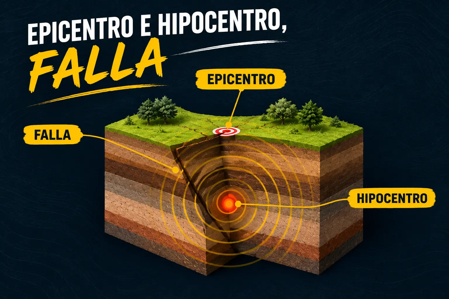
The epicenter is the point on the Earth's surface directly above the location inside the Earth where the seismic rupture begins.
Therefore, when news indicates that the epicenter is located a certain distance from a city, it is providing a geographical reference on the surface.
However, the epicenter is not the point where the earthquake physically originates.
That point is called the hypocenter.
What is the hypocenter?
The hypocenter, also called the seismic focus, is the point inside the Earth where the rupture that generates the earthquake begins.
Its location is expressed using geographical coordinates and depth.
Therefore:
Hypocenter = the place where the rupture begins inside the Earth.
Epicenter = the point on the surface located directly above the hypocenter.
This difference is especially important when we analyze the depth of an earthquake.
The depth of an earthquake
Depth indicates the distance between the Earth's surface and the hypocenter.
The USGS classifies, for scientific purposes, earthquakes into three main groups based on their depth:
Shallow earthquakes: between 0 and 70 kilometers.
Intermediate earthquakes: between 70 and 300 kilometers.
Deep earthquakes: between 300 and 700 kilometers.
These categories are a classification used by the USGS and should not be interpreted as a direct scale of danger.
Is a deep earthquake less dangerous?
Not necessarily.
Depth is a very important factor, but it cannot solely determine the dangerousness of an earthquake.
In general, all other conditions being equal, a shallow earthquake can produce stronger ground motions on the surface near the source than an earthquake of the same magnitude located much deeper, because the waves have less distance to travel and undergo less attenuation.
The National Seismological Center of Chile points out that an earthquake occurring at 10 kilometers deep can be felt with greater intensity than one occurring at 50 kilometers, due to the attenuation of energy with distance from the source.
However, intermediate and deep earthquakes can also be felt over great distances and produce significant effects.
Therefore, we should not use depth alone to decide if an earthquake is dangerous.
Magnitude and Intensity: two different concepts
This is probably one of the most important differences we should know.
Magnitude measures the size of the earthquake.
Intensity describes the effects and strength of seismic shaking at a specific location.
The same earthquake can have a single magnitude but different intensities in different localities.
For example, imagine a magnitude 7.0 earthquake. A town located near the rupture zone might experience very high intensity, while another town hundreds of kilometers away might experience much less shaking.
That is why it is incorrect to say that “a magnitude 7 earthquake has intensity 7”.
They are different concepts.
The USGS and the National Seismological Center of Chile explicitly establish this differentiation.
What is the Mercalli scale?
The Modified Mercalli Intensity Scale describes the effects of an earthquake at a given location.
Unlike magnitude scales, which are calculated from seismic records, intensity relates to what people experience and the observable effects on buildings, objects, and terrain.
The scale uses Roman numerals from I to XII.
Generally:
I: the earthquake is not perceived by people.
II-III: weak motion, perceptible under certain circumstances.
IV-V: clearly perceptible motion and possible minor effects.
VI-VII: damage may appear in certain constructions.
VIII-IX: significant damage to vulnerable structures.
X-XII: extremely severe effects and widespread destruction in the most affected areas.
The exact interpretation of each degree depends on the scale used and the characteristics of the location.
In Chile, for example, the Modified Mercalli Intensity Scale with twelve levels is used.
Why does an earthquake produce more damage in some places than in others?
Magnitude is important, but it is not the only factor that determines damage.
Among the elements that can influence we find:
Earthquake magnitude.